In what has become a tradition, Peter and I traveled to the southwest this year for my birthday. I say for my birthday because it happens in February, but mostly we want sunshine and clear skies during this otherwise very dreary month.
 |
| Our home for the night. |
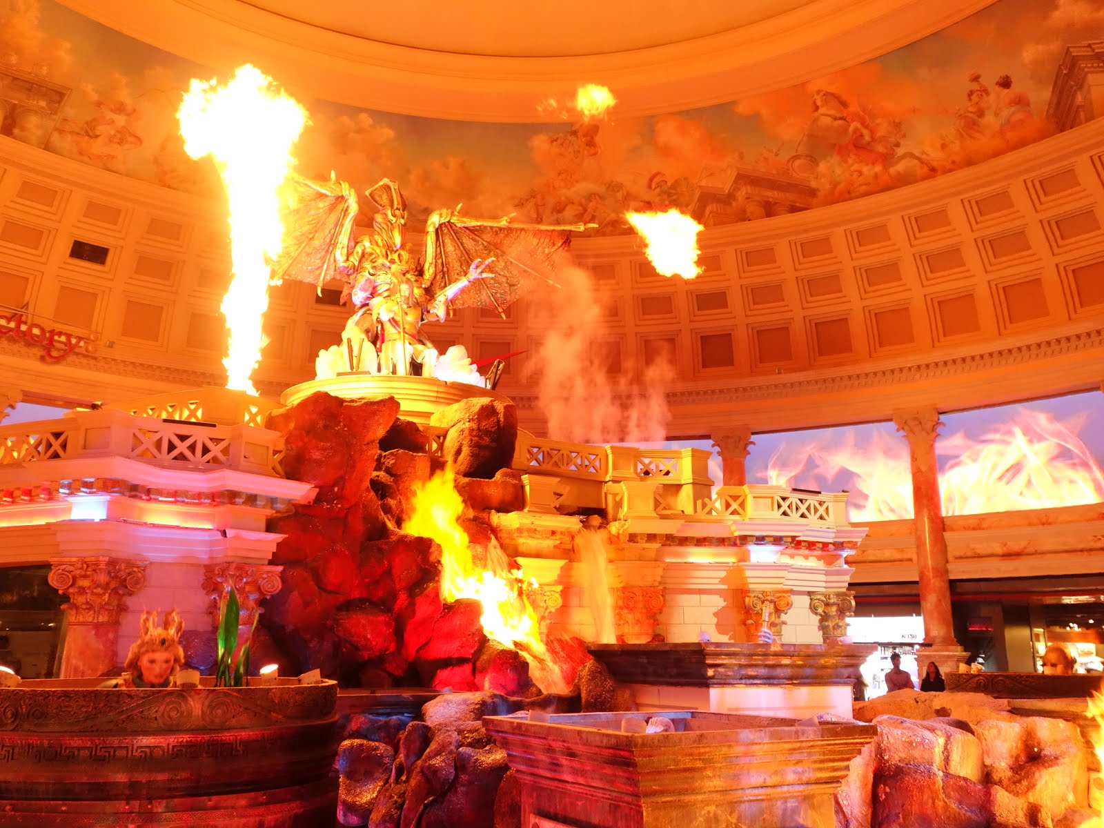
Touching down in Vegas on February 9th, we had our first (and most likely last) stay at a hotel on the strip: the Mirage. I haven't visited Vegas as an adult, and was apprehensive due to my general preference for quietude and living on the cheap. We arrived around dinner time and made it to the hotel by 7:30 pm after a last-minute gear trip to nearby REI (mostly to get fuel which is not allowed on the plane). We grabbed a burger at one of the multitude of restaurants inside of the casino and proceeded to walk around the strip for a couple hours. It was underwhelming, at best. Somehow we managed to walk around Caesar's Palace for a solid 90 minutes. It was overdone in all senses of the word. They even had a moving statue show.
 |
| Moving statue show. Inside. Real HOT fire. |
My favorite part of Vegas was the Bellagio fountains. We arrived just before a show started (they have something every 15 minutes) and it turned out to be an old favorite song of mine: Luck be a Lady by Frank Sinatra. We had a bit of whiskey and were briefly immersed in Vegas culture.
 |
| Bellagio fountains. |
Peter's favorite part of Vegas was 'his favorite woman posing with his favorite man'.
 |
| 'What's a good football pose?' |
The following morning we hightailed it to the
Grand Canyon. Unfortunately the time shift was not in our favor so our arrival was around 3 pm. I managed to leave my debit card at home... which was relevant because our starting trail head was some 22 miles east of the furthest trail head the shuttle buses served. The taxi service in the park only accepts cash (and $20 more than we had). After running around for a solid 45 minutes to an hour (with daylight slipping away), we came upon something which I never expected to be excited about: a chase bank. It turns out that large corporations are more than happy to take a cash advance off of your credit card.
By 5 pm we managed to make it to
Lipan Point - the easternmost trail head within the national park. With the sun quickly setting, we put on our yak tracks and hiked down between 1 and 2 miles, losing 1,500 feet on incredibly steep switchbacks, the trail covered in ice and snow. In our usual fashion, we hadn't eaten since breakfast time. That, with the temperatures below 40 degrees made for an intense climb down.
 |
| Descending from Lipan Point. Cold and dark on the trail. |
Worn down from the descent, we stopped for the night on
Sagittarius Ridge overlooking
Seventy-five mile creek to the west. In the distance to our east was
desert view - a tower we would have in our sights until the very last day of the trip.
 |
| Sagittarius Ridge at sunset. |
Sleeping on the first night of a trip is always the most difficult. This time around there were lots of unfamiliar sounds - most likely birds and mice (which were around several evenings) curious about our presence. One particular sound became the 'zipper bug' because it sounded like someone opening or closing a zipper. We got up early, anticipating the
Colorado River and it's cool water.
 |
| Hiking the last stretch of tanner trail down to the Colorado. Red dirt and yellowed grasses abound. |
Following a much needed break near the water, we started on our 'harder' goal for the trip: the
Escalante Route. The route, touting sections that require advanced route finding and slim pickings for water sources, meandered 12 miles between
Tanner trail and
New Hance trail. The first mile of trail gave us more confidence than the sparse online trail descriptions. We climbed through sandy, rock lined paths toward one of the obstacles we were cautioned against:
Papagos Creek.
 |
| First section of Escalante Route, heading toward (dry) Cardenas Creek. |
This part of the route was truly painless, following the river and generally not climbing more than 1,000 feet per mile. Arriving beneath
Dox Hill during the bewitching hour, we ditched our packs and eagerly climbed one last stretch to find the perfect spot.
 |
| First sunset on the Colorado. Hiking sans pack was effortless. |
We set up camp near the river as the light was quickly passing. After pitching the tent we took our dinner to the rocky beach, mesmerized by the sunset drenched cliffs.
 |
| Sunset on the Palisades, the reflection dancing on the Colorado. |
The next morning we awoke with anticipation of what was meant to be the most difficult stretch of trail for the next couple days. Despite the upcoming obstacles, the early morning light greeted us, our favorite time for hiking and picture taking in the Grand Canyon (which meant we were always chasing the very short days until the last possible moment of light).
 |
| Near Cardenas Creek. The sunrise makes the water look more blue than daylight where it's a muddy brown. |
 |
| Peter caught in the act. |
It was very difficult to make what was supposed to be quick progress with the incredible lighting we had on the hills. In fact, we found this to be the case on at least 75% of the trail and intend to never plan more than 5 miles of hiking per day while in the Grand Canyon.
 |
| Morning light playing on the hills near Cardenas Creek (larger image). |
 |
| Ritual morning ablutions. |
After breakfast, we climbed Dox Hill - according to the trail description we should have only climbed 800 feet over the course of the entire Escalante Route. This hill was at least 1000 feet, but worth the views.
We were to pass a section through which the trail description said 'there are many places where you will want to avoid a misstep at all cost.' Just a couple sentences later, however, we learn that 'the exposure may appear dramatic but is truly comfortable hiking'. You be the judge.
 |
| Start of the 'no mistakes allowed' section. |
With the intense heat, I donned my 'towel skirt' which is just our lightweight towel around my waist, hanging on the more sunny side of my legs. We don't have to bring as much sunscreen and it keeps things nice and cool. I know, you're jealous.
 |
| Hiking down into the Escalante Canyon. |
 |
| Climbing down the short arm of the Escalante Canyon, views of the Tabernacle. |
 |
| Final sunlight in the canyon, approaching camp. |
This was the 12th of February - which happens to be my little brother's birthday. I realized once we dropped into the canyon on the 10th that I had forgotten to tell him happy early birthday and was concerned he would think I forgot. I spent the day trying to think of what I could do to tell him - we forgot our pens in the car. The next best thing? (non permanent) Rock-art.
 |
| Happy Birthday Thomas :) |
 |
| Desert sky filled to the brim with stars. The moon was gradually giving us more light every evening. |
We spent the evening at the end of the Escalante drainage, near the Colorado. We planned to get a very deep night sleep as the following afternoon was meant to be the most difficult section of the route.
 |
| Approaching Seventy-five mile canyon, the final drainage before we reached Papagos Creek. |
 |
| Seventy-five mile canyon. Cold and deep. |
The canyon was a welcome change from the intense heat of the day. Simuno granite was everywhere, soft and smooth to the touch.
 |
| Simuno granite in Seventy-five mile canyon |
 |
| Climbing through the labyrinth of rocks in Seventy-five mile canyon |
 |
| Finally making it to the end of Seventy-five mile canyon |
After sauntering through Seventy-five mile canyon we were faced with our much-anticipated Papagos wall and talus slide. The guide told us ropes were required to hoist our packs up the 300 feet, consisting of several smaller shelves. We actually didn't use the rope and were feeling pretty good once we made it to the top.
 |
| Peter climbing up Papagos wall. |
With the climb behind us, however, we faced what would be the most intense descent I've ever experienced - a Talus slide or rock fall. If you're unfamiliar, talus is a very slippery, smooth rock. Prone to breaking up into irregular shapes that slide all over the place. We had to climb back down the 300 feet. The Colorado had gained significant speed below as it was very narrowly sandwiched between sheer, dark cliffs - falling down this talus field could have easily resulted in very serious injury.
There are no pictures of this section taken by us because it took us at least an hour to go less than a half mile. Peter stayed right ahead of me, no more than 3 steps away. I could feel my heart beating with such intensity that I would have to stop and remind myself to breathe every few minutes. My hands were clammy enough to cause me to slip around and my legs and feet trembled so much that Peter had to help me move my feet down to the right spot at some points.
My pack felt heavier than ever on this small section of the route - pushing me further than I wanted to go with each step. I started sliding at one point and couldn't stop myself moving for long enough that I nearly lost it - both emotionally and psychologically (it probably lasted less than 10 seconds). We finally made it off the rock and Peter was at the ready with our whiskey - I am beyond grateful for his patience with me on this section in particular. I couldn't feel my legs still and it wasn't until we hit normal trail that I could actually calm my heart and my breathing and my body finally gave in to some very relieving tears.
Once we made it to the Colorado we took a much needed break, filling all of our water. We had done it: we finished the Escalante route. And the amazing thing was that we had been hiking for 36 hours and hadn't seen a single person. Our lunch spot was at the start of the Tonto trail and a handful of rafts came through carrying several hikers.
 |
| Inviting rock garden. We did not want to leave this spot. |
Much later than expected, we started on the
Tonto trail - one of the more popular trails in the Grand Canyon. Despite having such a reputation, it was surprisingly difficult to find. We were rewarded with sweeping views and an incredible rock garden once we found it.
 |
| Just beyond the rock garden we walked along a well groomed trail, sad that we had to move so quickly (larger image). |
After a brutal day of hiking, we decided to enjoy sunset on the hills rather than hiking so quickly to our camp (not that we would have had much energy to do this in the first place).
 |
| Sunset at Mineral Canyon (larger image). |
 |
| Our reward for hiking up on to the butte above Mineral Canyon. |
Following sunset, we hiked a very dark 2 hours to
Hance Creek. Initially we hoped to use moonlight but it ended up being too dark. We actually hiked near our campsite from last year up on
Horseshoe Mesa. It was for the best that this section of trail was done in the dark because the trail here was especially steep and there was quite a fall to the canyon below.
 |
| Note the snow on the cliffs in the distance - near last year's Red Wall - an incredibly sheer exposed canyon trail. |
We had finally made it to the Tonto trail proper - a trail who's overall elevation gain is minimal. This meant easier hiking and quietude... less concern with where we put our feet and the ability to admire the canyon as we walked (rather than staring at our feet to avoid missteps).
 |
| Hance Canyon. Horseshoe mesa in the distance (larger image). |
We walked slowly, enjoying the morning. We never saw any large animals (only mice, squirrels and birds) but we saw a lot of animal remains.
 |
| Big horn from a... ram? |
There weren't many things in the desert that didn't have spikes or very dry scratchy edges. A particular pokey plant showed up a lot. It would split and these tiny hair like fibers would spiral away. If you touched the fibers they would break off.
 |
| Narrow leaf yucca plant close-up. |
We were eager to re-visit
Cottonwood canyon after it left a very cozy, relaxing impression the last time we came through. This trip it was equally beautiful and worth the hike. We ended up spending several hours here mid-day - a key to desert backpacking is to stop during the heat of the day if you can.
After our afternoon siesta we made our way toward
Grapevine creek - our planned destination for the evening. We were moving very slowly and found it too difficult to hike all the way. Instead, we found a beautiful spot beneath Horseshoe Mesa to spend the night. We enjoyed sunset view across the canyon.
 |
| Sunset from the promontory near our camp |
 |
| Looking west, cold canyons of Granite Gorge warning all those who dare to enter. |
 |
| Enjoying the view, Newberry Butte in the distance (larger image). |
 |
| View toward our starting point. Desert view just barely visible on the South Rim. |
The following morning we hiked to the most surprising spot along the trail: Grapevine Creek. The hike in was deceptively long. It took us nearly 2 hours to get back to the creek even though we could hear it much sooner than that.
 |
| Grapevine creek, an oasis in the desert. |
It was our final evening in the Grand Canyon. A bittersweet time. 5 days carrying our possessions on our backs - relying on no one else. The desert had brutalized us. We could barely handle a one mile per hour pace. We had to get as far as we could to break up the climb out of the canyon. Based on how slowly we'd been going before, we knew we'd need every bit of buffer we could manage.
 |
| Utah Agave. An incredible plant that sprouts seed-filled stalks over 10 feet. |
The final night, we decided to change our routine: why not have dinner a couple hours before camping? This meant we could enjoy one of the buttes at sunset, rather than climbing back into the gulleys (where we had to camp to get water) right away. It was a very satisfying change.
 |
| Sunset near Lonetree canyon. |
 |
| Hiking in to Lonetree canyon - our last spot to get water on the trail. |
We had 10 miles to hike back to the trail head in the morning. We knew it would be hot, and even though the climb section of the trail was less than 5 miles, it would be difficult. We planned to set our alarm for 5 am, anticipating arrival at the
South Kaibab trail around 9 am. In the end, we changed it to 6 (hiking in the dark, we decided, isn't very pleasant).
 |
| Peter sterilizing our last load of water. |
Over these 10 miles there would be no trace of water. That meant we had to carry 5 liters of water. We cooked two meals as well, adding another liter of weight. The morning hiking was surprisingly easy going. There were some difficult spots to cross within the last mile before we arrived at the trail split which added some significant effort and time that we hadn't anticipated.
 |
| Beautiful sunlit cacti near (dry) Cremation Creek. |
In our usual fashion, we didn't eat enough. The hike up was difficult, at best. We stopped whenever there was shade (not often) and tried to force ourselves to eat. It was hot. The shade was cold enough to bring us to shivers (likely due to lack of calories). We were hiking as hard as we could to get out of the canyon before the mid-day sun came to offer one final brutal hit. We waited too long to have 'lunch' and were joined by a very persistent raven.
 |
| Raven sat with us the entire time we had lunch. |
About half way up, we finally got our couple's photo (thanks to a very friendly hiker on the trail - there were hundreds to choose from).
 |
| Tired and weary, we had just crested Skeleton point. |
Once we made it out of the canyon, we went to the visitor center to find a place to stay for the night with one goal: a shower and some shade. It was hot. We had both suffered mild heat stroke on the hike out. It felt impossible to move our legs. The shade was so cold it was painful. After checking in at the
Yavapi Lodge and inhaling burgers, we went for a walk at sunset on the rim trail.
 |
| Walking along the rim trail near Yavapi Point. |
 |
| Beautiful tree at sunset near Yavapi point. |
We enjoyed a pretty spectacular night sleep in an insanely comfortable bed which was actually very quiet and out of the way (which we prefer). The following morning we drove to
Hopi point. We wanted to walk along the rim trail but our legs were finally entirely devastated.
After the morning walk, we returned to our room for some breakfast and final packing. We were very slow and it was pretty satisfying. Our checkout time was 11 and we stayed until 11:30, enjoying the shelter from the sun.
 |
| Very cozy room at Yavapi Lodge. |
After checking out, we wanted to go somewhere quiet to enjoy the canyon for a couple hours before we had to drive back to Vegas to catch our flight. After we arrived at the rim the night prior, there were way too many people, too much noise, and too much going on. It was a shock to the system and not a very pleasant one. The afternoon ended up being beautiful (albeit incredibly windy) at
Shoshone point.
 |
| The clouds were spectacular, looking toward the massive north rim. |
So that was it - 6 days and 6 nights in the Grand Canyon. Over 55 miles, highs above 70 and lows reaching below freezing. It was incredible. We plan to explore the north rim and have every intention of visiting next February. And the February after that. Pretty great for a birthday trip if you ask me.
Full album of photos can be viewed
here.


